Grove - GPS
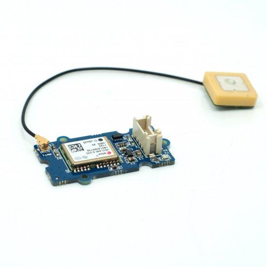
这款 Grove - GPS 模块是一个成本效益高且可现场编程的设备,配备了 SIM28(u-blox 6 是旧版本)和串行通信配置。它具有 22 个跟踪 / 66 个捕获通道的 GPS 接收器。跟踪和捕获的灵敏度都达到了 -160dBm,使其成为个人导航项目和位置服务的绝佳选择,也是同价位产品中的杰出产品。
我们已经发布了 Seeed GPS 模块选择指南,它将帮助您选择最适合您需求的 GPS 模块。
版本
| 产品版本 | 变更 | 发布日期 |
|---|---|---|
| Grove - GPS V1.2 | 初始版本 | 2015年10月 |
特性
- 支持 NMEA 和 u-blox 6 协议。(直到2014年1月10日,之后改为 SIM28)
- 低功耗
- 波特率可配置
- Grove 兼容接口
有关 Grove 模块的更多详细信息,请参考 Grove 系统
规格参数
| 参数 | 范围/值 |
|---|---|
| 输入电压 | 3.3/5V |
| 波特率 | 4800 - 57600(u-blox 版本) |
| 波特率 | 9600 - 115200(SIM28 版本) |
| 默认波特率 | 9600 |
支持的平台
| Arduino | Raspberry Pi | |||
|---|---|---|---|---|
上述提到的支持平台是/是该模块软件或理论兼容性的指示。在大多数情况下,我们只为 Arduino 平台提供软件库或代码示例。不可能为所有可能的 MCU 平台提供软件库/演示代码。因此,用户必须编写自己的软件库。
开始使用
如果这是您第一次使用 Arduino,我们强烈建议您在开始之前先查看 Arduino 入门指南。
与 Arduino 配合使用
此示例通过软件串口简单地从 GPS 读取数据,并将其发送回串口。
硬件
- 步骤 1. 准备以下物品:
| Seeeduino V4.2 | Base Shield | Grove - GPS |
|---|---|---|
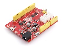 | 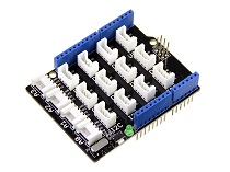 |  |
| 立即获取 | 立即获取 | 立即获取 |
- 步骤 2. 将 Grove - GPS 连接到 Grove-Base Shield 的 D2 端口。
- 步骤 3. 将 Grove - Base Shield 插入 Seeeduino。
- 步骤 4. 通过 USB 线将 Seeeduino 连接到 PC。

如果我们没有 Grove Base Shield,我们也可以直接将 Grove - GPS 连接到 Seeeduino,如下所示。
| Seeeduino | Grove - GPS |
|---|---|
| 5V | Red |
| GND | Black |
| D3 | White |
| D2 | Yellow |
软件
请注意,u-center 软件仅适用于 Windows。
#include <SoftwareSerial.h>
SoftwareSerial SoftSerial(2, 3);
unsigned char buffer[64];                   // buffer array for data receive over serial port
int count=0;                                // counter for buffer array
void setup()
{
    SoftSerial.begin(9600);                 // the SoftSerial baud rate
    Serial.begin(9600);                     // the Serial port of Arduino baud rate.
}

void loop()
{
    if (SoftSerial.available())                     // if date is coming from software serial port ==> data is coming from SoftSerial shield
    {
        while(SoftSerial.available())               // reading data into char array
        {
            buffer[count++]=SoftSerial.read();      // writing data into array
            if(count == 64)break;
        }
        Serial.write(buffer,count);                 // if no data transmission ends, write buffer to hardware serial port
        clearBufferArray();                         // call clearBufferArray function to clear the stored data from the array
        count = 0;                                  // set counter of while loop to zero
    }
    if (Serial.available())                 // if data is available on hardware serial port ==> data is coming from PC or notebook
    SoftSerial.write(Serial.read());        // write it to the SoftSerial shield
}


void clearBufferArray()                     // function to clear buffer array
{
    for (int i=0; i<count;i++)
    {
        buffer[i]=NULL;
    }                      // clear all index of array with command NULL
}
-
步骤 3. 打开 U-center。
-
步骤 4. 点击 Receiver -> Port 并选择 Arduino 正在使用的 COM 端口。
-
步骤 5. 点击 Receiver -> Baudrate 并确保选择了 9600。
-
步骤 6. 点击 View -> Text Console,您应该会得到一个显示 NMEA 数据流的窗口。
-
步骤 7. 打开串口监视器,您可以看到如下所示:

我们也可以在 Google Earth 中查看数据:
-
步骤 1. 点击 File -> Database Export -> Google Earth KML
-
步骤 2. 这应该会启动 Google Earth,显示 u-center 捕获的历史记录。
-
步骤 3. 或者,可以通过按工具栏上的红色圆圈来记录数据,然后会询问您要将记录保存在哪里。
-
步骤 4. 当我们捕获了足够的数据后,点击黑色方块停止记录。
-
步骤 5. 然后我们可以通过将生成的 .ubx 文件上传到 GPSVisualizer 来将其转换为 KML。
与 Raspberry Pi 配合使用
硬件
- 步骤 1. 准备以下物品:
| Raspberry pi | GrovePi_Plus | Grove - GPS |
|---|---|---|
 |  | |
| 立即获取 | 立即获取 | 立即获取 |
- 步骤 2. 将 GrovePi_Plus 插入 Raspberry。
- 步骤 3. 使用 grove 线缆将传感器插入 grovepi+ 的 RPISER 接口。
- 步骤 4. 通过 USB 线缆将 Raspberry 连接到 PC。

软件
-
步骤 1. 按照 设置软件 配置开发环境。
-
步骤 2. 导航到演示目录:
cd ~
git clone https://github.com/DexterInd/GrovePi.git
cd GrovePi/Software/Python/grove_gps
- 步骤 3. 查看代码
nano grove_gps_data.py # "Ctrl+x" 退出 #
import serial, time
import smbus
import math
import RPi.GPIO as GPIO
import struct
import sys
#import ir_receiver_check

enable_debug=1
enable_save_to_file=0

#if ir_receiver_check.check_ir():
# print("Disable IR receiver before continuing")
# exit()

ser = serial.Serial('/dev/ttyAMA0',  9600, timeout = 0) #Open the serial port at 9600 baud
ser.flush()

def cleanstr(in_str):
 out_str = "".join([c for c in in_str if c in "0123456789.-" ])
 if len(out_str)==0:
  out_str = "-1"
 return out_str

def safefloat(in_str):
 try:
  out_str = float(in_str)
 except ValueError:
  out_str = -1.0
 return out_str

class GPS:
 #The GPS module used is a Grove GPS module https://www.seeedstudio.com/depot/Grove-GPS-p-959.html
 inp=[]
 # Refer to SIM28 NMEA spec file https://www.seeedstudio.com/wiki/images/a/a0/SIM28_DATA_File.zip
 GGA=[]


 #Read data from the GPS
 def read(self):
  while True:
   GPS.inp=ser.readline()
   if GPS.inp[:6] =='$GPGGA': # GGA data , packet 1, has all the data we need
    break
   time.sleep(0.1)     #without the cmd program will crash
  try:
   ind=GPS.inp.index('$GPGGA',5,len(GPS.inp)) #Sometimes multiple GPS data packets come into the stream. Take the data only after the last '$GPGGA' is seen
   GPS.inp=GPS.inp[ind:]
  except ValueError:
   print ("")
  GPS.GGA=GPS.inp.split(",") #Split the stream into individual parts
  return [GPS.GGA]

 #Split the data into individual elements
 def vals(self):
  if enable_debug:
   print(GPS.GGA)

  time=GPS.GGA[1]

  if GPS.GGA[2]=='':  # latitude. Technically a float
   lat =-1.0
  else:
   lat=safefloat(cleanstr(GPS.GGA[2]))

  if GPS.GGA[3]=='':  # this should be either N or S
   lat_ns=""
  else:
   lat_ns=str(GPS.GGA[3])

  if  GPS.GGA[4]=='':  # longitude. Technically a float
   long=-1.0
  else:
   long=safefloat(cleanstr(GPS.GGA[4]))

  if  GPS.GGA[5]=='': # this should be either W or E
   long_ew=""
  else:
   long_ew=str(GPS.GGA[5])

  fix=int(cleanstr(GPS.GGA[6]))
  sats=int(cleanstr(GPS.GGA[7]))

  if  GPS.GGA[9]=='':
   alt=-1.0
  else:
   # change to str instead of float
   # 27"1 seems to be a valid value
   alt=str(GPS.GGA[9])
  return [time,fix,sats,alt,lat,lat_ns,long,long_ew]

 # Convert to decimal degrees
 def decimal_degrees(self, raw_degrees):
  try:
   degrees = float(raw_degrees) // 100
   d = float(raw_degrees) % 100 / 60
   return degrees + d
  except:
   return raw_degrees


if __name__ == "__main__":
 g=GPS()
 if enable_save_to_file:
  f=open("gps_data.csv",'w') #Open file to log the data
  f.write("name,latitude,longitude\n") #Write the header to the top of the file
 ind=0
 while True:
  time.sleep(0.01)
  try:
   x=g.read() #Read from GPS
   [t,fix,sats,alt,lat,lat_ns,longitude,long_ew]=g.vals() #Get the individial values

   # Convert to decimal degrees
   if lat !=-1.0:
    lat = g.decimal_degrees(safefloat(lat))
    if lat_ns == "S":
     lat = -lat

   if longitude !=-1.0:
    longitude = g.decimal_degrees(safefloat(longitude))
    if long_ew == "W":
     longitude = -longitude

   # print ("Time:",t,"Fix status:",fix,"Sats in view:",sats,"Altitude",alt,"Lat:",lat,lat_ns,"Long:",long,long_ew)
   try:
    print("Time\t\t: %s\nFix status\t: %d\nSats in view\t: %d\nAltitude\t: %s\nLat\t\t: %f\nLong\t\t: %f") %(t,fix,sats,alt,lat,longitude)
   except:
    print("Time\t\t: %s\nFix status\t: %s\nSats in view\t: %s\nAltitude\t: %s\nLat\t\t: %s\nLong\t\t: %s") %(t,str(fix),str(sats),str(alt),str(lat),str(longitude))

   s=str(t)+","+str(safefloat(lat)/100)+","+str(safefloat(longitude)/100)+"\n"

   if enable_save_to_file:
    f.write(s) #Save to file
   time.sleep(2)
  except IndexError:
   print ("Unable to read")
  except KeyboardInterrupt:
   if enable_save_to_file:
    f.close()
   print ("Exiting")
   sys.exit(0)
- 步骤 4. 运行演示程序。
sudo python grove_gps_data.py
注意
GPS 在户外使用效果更好。建议将您的树莓派放在窗外或任何户外场所。SIM28 模块说明
- 步骤 1. Grove-GPS 已将模块更换为 SIM28,其封装与原版本相同。
- 步骤 2. 我们应该使用 "SIMCom GPS DEMO" 工具来接收 SIM28 模块数据。
- 步骤 3. 打开 SIMCom_GPS_DEMO 工具,转到 Module->properties->module->选择 SIM28。
- 步骤 4. SIMCom_GPS_DEMO_V1.07 仅适用于 Windows 系统。

- 步骤 5. 打开 SIMCom_GPS_DEMO 工具,转到 Module->connect。选择 GPS 模块使用的串口。

原理图在线查看器
资源
- [Eagle] Grove-GPS Eagle 文件
- [PDF] GPS 原理图(PDF)
- [数据手册] E-1612-UB 数据手册
- [数据手册] U-Blox6 接收器描述协议规范
- [软件] U-Blox u-center GPS 评估软件
- [文档] SIM28_DATA_File
- [文档] SIMCom_GPS_DEMO_V1.07
项目
GPS/GPRS 追踪器项目:在这个新项目中,我们将展示使用 GPRS 技术和 MQTT 协议连接的 GPS 追踪器。
技术支持与产品讨论
感谢您选择我们的产品!我们在此为您提供不同的支持,以确保您使用我们产品的体验尽可能顺畅。我们提供多种沟通渠道,以满足不同的偏好和需求。